Description
From the valley basin in Puchberg, you hike comfortably at the foot of the Schneeberg up to the first ascent to the Fadensattel. This route is characterized by the Schneeberg, which you always keep in sight, and by rural cultural landscapes, until you finally come face to face with the highest mountain of the Vienna Alps at the Fadensattel. Already at the beginning of the stage at the train station, you have the first great view of the Schneeberg. In Losenheim, the second view of the highest mountain in Lower Austria and the Losenheim castle ruins are revealed. The ascent to the Fadensattel can also be done using the chairlift.
Starting point of the tour
Parking lot of the Schneeberg cable car in Puchberg am Schneeberg
Destination point of the tour
Edelweißhütte
Route description WAB - Regional Route P: Puchberg - Edelweißhütte
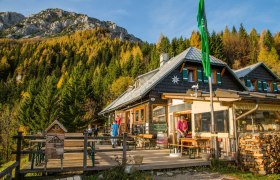
The leisurely ascent to the Fadensattel on the Regional Route P starts at the Puchberg am Schneeberg train station, from where we hike a few meters alongside the tracks back to Wiener Neustädter Straße. In front of us, we see the certified hiking establishment Hotel Schneeberghof, where you can spend the night if arriving the day before and start the day with a tasty hiking breakfast. At the street, we turn north, cross the railway tracks, then shortly afterwards turn left into Siebertweg and follow the yellow signposts towards Losenheim. From here, for several kilometers, we are also accompanied by the red-marked Burgenland Mariazellerweg. At the end of Siebertweg, we turn right into Paradiesweg and only seconds later continue left into Römerweg. At some resting benches, a signpost leads us half-right off the road and takes us over a pasture. We then walk westwards on peaceful asphalt and gravel roads, before the Mariazellerweg leaves us at an intersection with a transformer station, turning right. We follow the asphalt road to the left, which two bends later merges into the road to Losenheim. In the hamlet Sonnleiten, we follow the road to Wasserfallwirt, but soon afterwards leave it to the left after a gravel parking lot at a farmstead crossing the Sebastianbach and follow the yellow markings. Step by step we get closer to the Schneeberg; inevitably, we end up back on the road to Losenheim. On the left towers the ruin of Losenheim, which has been privately restored since the 1990s. We reach the village of Losenheim with the hiking hotel Forellenhof, pass through it and continue ascending the road to the parking lot of the Schneeberg chairlift. Here there is the option to shorten the ascent to the Fadensattel with the chairlift. However, we hike uphill to the end of the road and follow the yellow-marked and signposted ascent path to the Edelweißhütte and Almreserlhaus. After some switchbacks, ski slope ascents, and a pasture crossing, the gravel path briefly levels out. On the left is now the Edelweißhütte at the foot of the Fadensteig, and on the right the Almreserlhaus, both inviting you throughout the year to rest and refresh. Here also ends Regional Route P.
Here we meet the path along the Vienna Alpine Arc and can either continue hiking to the Öhlerschutzhaus or ascend to the Fischerhütte on the Schneeberg. Overnight stays at the Edelweißhütte or in the Almreserlhaus are also possible. Regional Route O also starts here.
Directions
If coming from Vienna and Graz, take the A2 to the exit Wr. Neustadt West. Take the B26 to Puchberg am Schneeberg. A road leads to the valley end to the chairlift at Losenheim.
Parking
Parking spaces available at the Puchberg am Schneeberg train station.
Travel by train via Wiener Neustadt to the Puchberg am Schneeberg station or by public bus.
For more information, visit www.VOR.at


